Showing posts with label France. Show all posts

Friday, 8 December 2017

Corsica's finger Tour

A travel story of Skeletor

Unexpected things are always the best. Alfio and Antonello, friends of my wife propose a weekend with mini cruise in Corsica, we are in autumn, the ferries have few reservations and for several years a group of motorcyclists organizes weekends on the island.

Saturday, 28 October 2017

Autumn on the Tour de France roads - 3rd Stage: Col de l'Izoard and Col du Montgenevre

We thought and discussed last night largely whether to end the tour either with the Agnello Pass or with the Montgenèvre Pass, we were very perplexed about the Agnello Pass, the awakening made us all clearer. A bit 'of rain, but especially the night white stomach problems have made the decision easier.

Tuesday, 24 October 2017

Autumn on the Tour de France roads - 2nd Stage: Col du Telegraphe and Col du Galibier

Early this morning, breakfast is waiting for us at 7.30am. The hotel manager has given us the chance to have breakfast at 7.30 am, unusual here, generally breakfast is available in the hotels from 8 am this however for travel with bicycle is a problem, it means that you can not be ready before the 9.00 am to start.

Saturday, 14 October 2017

Autumn on the Tour de France roads - 1st Stage: Col du Mont Cenis

To pedal and train seriously there is always a need for a goal, and then here I am, I have created one, a beautiful journey between the colors of Autumn in the mountains in the company of friend of mine Lorenzo. It was a while that I did not ride a multi-day trip, the last one year ago to Cornaley with Lorenzo.

Tuesday, 18 September 2012

Sunday, 16 September 2012

Col de L'Iseran (Day 3)

The accommodation in Aigueblanche was perfect up to the breakfast moment. I did not expect such a poor breakfast; the old lady didn't play too much attention to me and served me only tea and few bread and croissant. How could I start riding for a 50 km uphill with this breakfast? I asked for ham and cheese, she brought them to me but she was not happy at all, it looked like an unusual request. I asked for extra bread but I think it was too much for her and I did not ask any further. I had a second breakfast in Bourg St Maurice and the overall food was not bad.


The route from Aigueblanche to Aime and Bourg St Maurice is really strange because it looks like and highway, with bridges and tunnels but it has bike lane, very strange feeling, I felt safer there than in other narrow road actually.
From Bourg St Maurice a sign says 43 km to Col de l'Iseran that means more or less the same amount of uphill. Bon curage as the French says. The landscapes don’t miss here and the Lac du Chevril below Tignes offered beautiful blue colour to the mountains frame.


After an huge lunch in Val d'Isere I started the uphill towards the top, the last 17 km, the most impressive 2770 m of Col De L’Iseran. .
On the way up I met a really nice American cuboviaggiatore. I hope he doesn't mind I call him cuboviaggiatore, just joking, we had a nice and really pleasant chat. He is travelling with a Panda around Italy, big challenge!! (My old Panda will thank him). So please American friend stay in contact I would love post some picture of your trip.

The satisfaction on the top was great not possible to describe with words, maybe pictures can do it better. Long downhill toward Lanslevillard, where I had a pleasant evening with UK friends

GPS TRacking


Saturday, 15 September 2012

Col de la Madeleine (Day 2)

The weather was beautiful and the breakfast abundant.

Starting with the long slow downhill up to St. Jean d Maurienne (actually La Chambre), nothing remarkable except for another strange kind of Cuboviaggiatore, travelling with donkey, great man!!! Never know, my bike sometimes is like a donkey as well ... maybe dependent on my legs.

Friday, 14 September 2012

Last minute. Maurienne tour (Day 1)

The Moncenisio uphill one of the longest I have never ridden. The Italian side unfortunately is not well maintained even if the landscape is wonderful. There are many buildings abandoned and nor easy to find a place where having food.

I found out only a snack bar which served me a sandwich with bread one day old. The lady tried to make it fresh again putting in the oven... we can discuss about the result.


Almost arrived on the top a strong wind put me in difficulties even to stand and keep bike balance, sometimes I had to walk and the temperature went down up to 9 degrees with even lower perception, but this is was not a problem with my full luggage with me.

What to say about the lake? Always fascinating place and a good subject for pictures.
The Moncenisio Lake with the italian side in the background
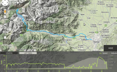
GPS Tracking


Complete Photo Album 


Wednesday, 5 September 2012

The giant of the Alps (Col De l'Iseran)

Bonneval sur l'Arc is the starting point for the south side of the Col de L'Iseran uphill, actually I started from Lanslevillard 30 kms away from the Col de L'Iseran top. Once arrived in in Bonneval I notice in the big welcome sign that it is twin town of Le Baux de Provence... I felt a cold sweat.

Friday, 30 September 2011

From the Alps to Mont Ventoux (1st Edition)


Salita al Monte Ventoso


Oggi, spinto dal solo desiderio di vedere un luogo celebre per la sua altezza, sono salito sul più alto monte di questa regione, chiamato giustamente Ventoso. 
...
La mole del monte, infatti, tutta sassi, è assai scoscesa e quasi inaccessibile, ma ben disse il poeta che «l’ostinata fatica vince ogni cosa»
[F. Petrarca] 

Overall Tour

Day 1: Cuneo - La Roure (102 Km)
Day 2: La Roure - Castellane (105 Km)
Day 3: Castellane - Greoux Les Bains (77 Km)
Day 4: Greoux Les Bains - Arles (135 Km)
Day 5: Arles - Carpentras (70 Km)
Day 6: Carpentras - Nyons (84 Km)
Day 7: Nyons - Gap (108 Km)
Day 8: Gap - Barcellonnette (68 Km)
Day 9: Barcellonnette - Cuneo (110 Km)


Visualizzazione ingrandita della mappa

Day 1
Cuneo - La Roure (102 Km)

Highlights

Col De La Lombarde:  (2.350 m s.l.m.) is amountain pass at the border between France and Italy in the Maritime Alps.
The uphill is one of the most impressive in the Alps. The uphill is 21.7 Km long with an average inclination of 6.8% and a maximum of 14%. On the Italian side you can see on your way the San Anna Sanctuary, the highest in Europe. On the French side you will find on your way the ski resort area of Isola 2000. The Tour de France passed here in the 2008 in the Cuneo - Jausiersstage which was won by Stefan Schumacher.

On your path the road will pass across the Parc National Du Mercantour that is located on the extrem south-east part of France just close by Piedmont, it is one of the 9 national parc in France. The Parc National Du Mercantour includes the following valleys which some of them will be crossed in the following days:


Gorges de la Valabres: Road characterized by red rocks with tunnels in the rocks.


La Roure: it is a small town in the Maritime alps in the region of Alpes-de-Haute-Provence with 219 people, from here the view is wonderful, it is recommended to stay at the Auberge Le Robur (Booking).


Route

Altitude Profile

Hotel info
Name: Auberge Le Robur
Website: http://www.aubergelerobur.fr/index_083.htm
Address: Rue Centrale, Roure, 06420, France
Phone: +33493020357
Email: lerobur@free.fr


Day 2
La Roure - Castellane (105 Km)

Highlights

Roubion It is a sall town which dominate the Vionène valley and laying on the rock.


The first uphill of the day is the Col de la Cuillole (m 1678). During the uphill is possible to see the typical middle age village of Roubion.


Gorges du Cians: The cians is a small river confluent to the Var, but is famous because crossing the spectacular Gorges.

Today additional highlights:
Col de Toutes Aures
Lac de Castillon
Castellane
Route


Altitude Profile


Day 3
Castellane - Greoux Les Bains (77 Km)

Highlights

Gorges du Verdon: it is the canyon formed by Verdon river, it is considered one of the best of Europe. The canyon is 25 Km long and 700 meters height.
The river name derive by its colour. The most canyon interesting part is starting after the Castellane villageup to the Saint Croix Lake.

Lac de Saint Croix: The artificial lake formed by means of a dam build from 1971 to 1974 called Saint Croix barrage. The basin has a capacity of 761 million of water square meters and it is able to produce 142 million of KWh of electric energy per year.

Route (77 Km)

Altitude Profile


Adviced Hotel
Name: La Cheneraie
Website: http://www.la-cheneraie.com/
Address: Chemin Des Collines Bp32, Greoux Les Bains, 04800, France
Phone: +33492780323
Email: contact@la-cheneraie.com


Day 4
Greoux Les Bains - Arles (135 Km)

Highlights

Vinon Sur Verdon
Gorges de L'Infernet
Aix en Provence
Arles


Route


Altitude Profile

Hotel info
Name: Hôtel Résidence de la Transhumance
Website: http://www.hotel-transhumance.fr/
Address: 11, rue de la Transhumance, Saint Martin de Crau, 13310, France
Phone: +33490182970
Email: hotel-transhumance@orange.fr

Day 5
Arles - Carpentras (70 Km)


Route


Adviced Hotel info
Name: Les Demeures Du Ventoux
Website: http://www.lesdemeuresduventoux.com/
Address: Avenue Majoral Jouve Quartier De La Rodde, Aubignan, 84810, France
Phone: +33490361083
Email: AccDemeuresDuVentoux@village-center.fr

Day 6 (Thursday 29/09/2011) Mont Ventoux
Carpentras - Nyons (84 Km)

Il Mont Ventoux is a massif which peak can reach 1912 meters. It is called by the French "The Giant of the Provence", it is located airline 20 Km south from Carpentras and it is quite far away from other peak in the region.

The Mount Ventoux is classified "Biosphere Reserve" from the UNESCO inthe context of "MAB" (Man and Biosphere) project. The Mount Ventoux presents a specific flora and a rich fauna. The surranding hills are famous for the well-known table wine (Côtes du Ventoux).


Route

Altitude Profile

Hotel info
Name: La Picholine
Website: http://www.picholine26.com/
Address: Promenade de la Perriere Nyons, 26110, France
Phone: +33475260621
Email: picholine26@wanadoo.fr
Location: Latitude 44.36472, Longitude 5.13545 (N 044° 21.883, E 05° 8.127)

Links
http://www.salite.ch/ventoux2.asp
http://www.suipedali.it/
http://www.lemontventoux.net/  
http://www.climbbybike.com/

Day 7
Nyons - Gap (108 Km)

Highlights
Col De La Sauce

Route


Hotel info
Name: Hotel Pre Vert
Website: http://www.hotel-prevert-gap.federal-hotel.com/
Address: Belle Aureille - Micropolis Gap, 05000, France
Phone: +33492524584, +33492520691 (Fax)
E-mail: hotel-prevert@orange.fr

Day 8
Gap - Barcellonnette (68 Km)


Route (68 Km)


Altitude Profile

Hotel info
Name: Chalet Pra Loup
Website: http://www.chaletpraloup.fr/
Address: Les Molanes
Pra Loup 1500, 04400
France
Phone: +33676638440, +33492322226 (fax)
E-Mail: chaletpraloup.resa@yahoo.fr


Day 9
Barcellonnette - Cuneo (110 Km)


Route